
Lately I've been bored with it and decided to revisit a personal project which started when I got my reservist command, mainly to use for quick reference and confirmation when running night-time high speed exercises and sorties. I've plotted 460+ bouys/beacons (including their characteristics) in S'pore & Johor Straits up to the South China Sea and 12 tidal prediction stations around the island. Also put in reefs, wrecks, anchorage areas, traffic separation, terrirorial boundaries, port limits and soundings.
Will not incorporate this into the S'pore road map as it's for my personal use when I take my ship out for patrols during reservist.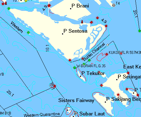
There are some limitations in the land version of cgpsmapper like nav aids not being searchable, unable to distinguish between bouys and beacons, cannot specify cardinal marks, etc. With the marine version, they show up as Nav Aids under Marine Points and bouy/beacon have detailed characteristic like foundation and light colour, light range and angle, light type, etc. There are 160 new dedicated marine types to play with.
Unfortunately, MapEdit doesn't handle these new types so will have to do the conversion manually with a text editor. Before the conversion, I'll some time going through the Notice to Mariners to bring the map up to date, some of the beacons leading into Marina Bay and Kallang Basin have been removed because of the Marina Barrage, some unlit bouys in the Johor Straits have been given characteristics.
The conversion process requires converting of the sounding contours, land masses to polygons and their type and colour specified. Lights, bouys and beacons have to be sorted out, re-classified according their type and markings, the new attributes have to be keyed in. Another thing to look into is Tide Prediction, even though the 12 tidal stations are there, the prediction data are not. I suspect it's due to the lack of harmonic and height info, even the marine version does not have the parameters to input these nor is it supported.